 GPS Assisted Content: the Appalachian Trail
Read this post and dream about the near future when we all can post GPS assisted travelogues on our blogs, perhaps even linked to Google maps which readers can use to zoom in on your location from the comfort of their desktop. Talk about Armchair travelogues.
Actually the future is here. But I have been too busy to check if Google and Flickr's co-venture works for me, the daffy non-techinal techie. Maybe you have more time on your hands than I do today to check out this video tutorial Geotagging Flickr photos with Google Earth Flickrmap tells us:
Google Earth is by far the best source of geographic information on the web. Combined with the Flickrmap Geotagger you can easily add geographic information or "geotags" to your own Flickr photos. Adding geotags allows you to use various web scripts and applications designed by the Flickr community.
Kentaro Toyama has this fascinating post on experiments using metadata and GPS positions to help create location-specific content and
...browse photos by time and location. As you navigate in the map panel to different parts of the globe and set the timeline to a particular time interval, the photos in the thumbnail panel show only those photos which were taken somewhere on the visible map and between the dates you selected.
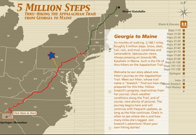
Check out Kodak's E-Story about one hiker's journey along the Appalachian Trail that was created with GPS data. To be honest Kodak's story of " Sneetch" hike is kind of boring. But the navigation is not if you think how it will soon be available for all to use routinely. Maybe even coupled with Google's Maps?
Kodak tells us,
Sneetch is our hiker's trail name. She's a young, married woman with an engineering background. She's taken a six-month leave of absence from her job, and with her husband, Scott's support and encouragement, is pursuing her goal of hiking the A.T.
After purchasing a GPS device, says Toyama, carry it on your person whenever you shoot photos. Handheld GPS units typically store a time-stamped record of where they've been, so it's possible to transfer the location data stored on the GPS device onto a photo by matching time stamps.
After downloading the Media eXchange Client you can begin to tag your not only with exposure data and a time stamp, but also with the GPS data. Later on that data can be utilized to help build a site such as Kodak did on the Appalachian Trail. The GPS locations are the literal links for navigation for the posts.
Once your photos are time-stamped and location-stamped, software allows you to take advantage of this information in a variety of ways. Software that can make sense of location-stamped photos is just now beginning to appear on the mainstream market. An experimental research project, The World Wide Media Exchange (wwmx) is an example of one *type* of software.
No comments:
Post a Comment